
Through the cause of overpopulation, respectively the increasing human numbers on earth which cannot be sustained naturally and balanced by the laws of nature, the effects this is causing to the environment can be clearly seen. The irresponsibility of the earth human in regard and towards the planet is destroying the environment due to the extent that flora and fauna species are becoming endangered and extinct. The damaged caused by overpopulation may take centuries and millennia to repair and re-grow if this is possible at all.
The damage caused by overpopulation to the environment is due to over consumption, urban sprawl, clearing of land for mass farming of animals used for food and crop growth, mining , pollution, climate change cause by pollution - deforestation - radiation - oil contamination and the reduction of oxygen in the atmosphere, just to name a few. In fact there are many different damaging effects to the environment which all have their roots solely in overpopulation.
The following is a visual presentation of the destruction to planet earth by human actions to try and sustain the increasing human numbers.
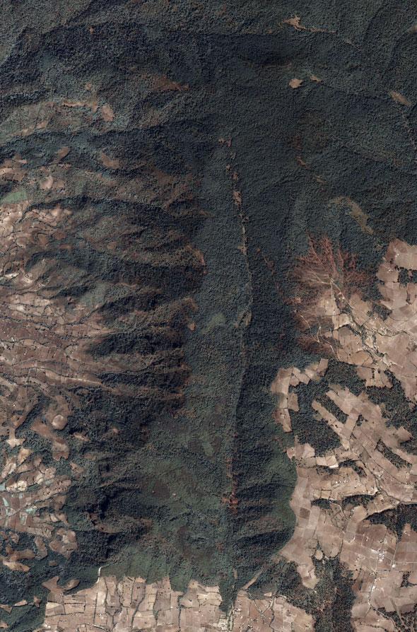
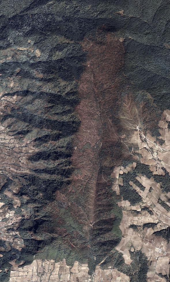
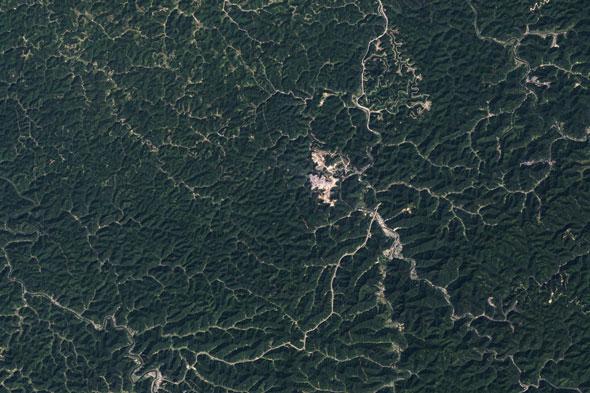
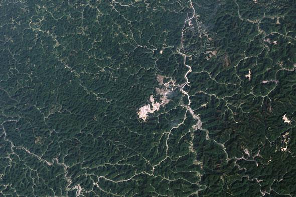
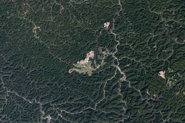
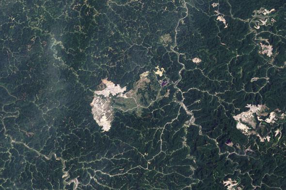
1. MEXICO'S MONARCH BUTTERFLY RESERVE
Brief Description:
The 56,259 ha biosphere lies within rugged forested mountains about 100 km northwest of Mexico City. Every autumn, millions, perhaps a billion, butterflies from wide areas of North America return to the site and cluster on small areas of the forest reserve, colouring its trees orange and literally bending their branches under their collective weight. In the spring, these butterflies begin an 8 month migration that takes them all the way to Eastern Canada and back, during which time four successive generations are born and die. How they find their way back to their overwintering site remains a mystery.
Illegal logging is destroying the Lomas de Aparicio monarch colony, where millions of monarch butterflies spend the winter. The NASA images show the loss of approximately 3.3% of the 33,410 core zone of the reserve lost to logging in just four years.
| 2004 | 2008 |
 |
 |
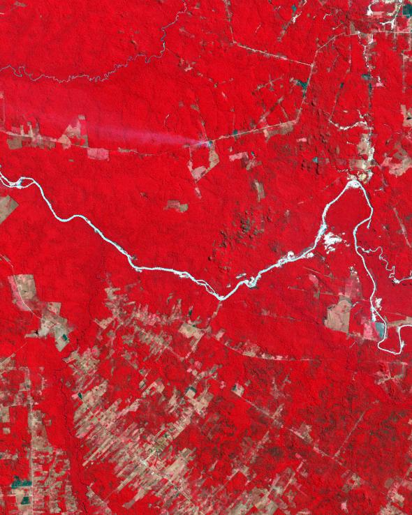
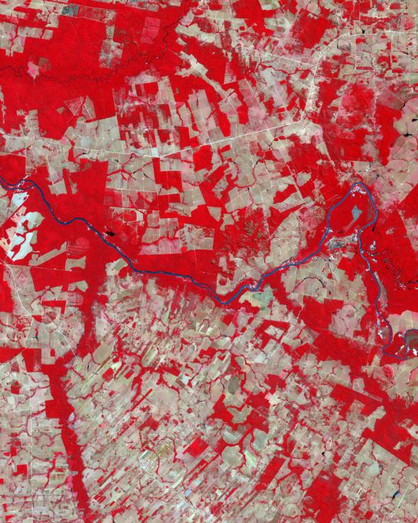
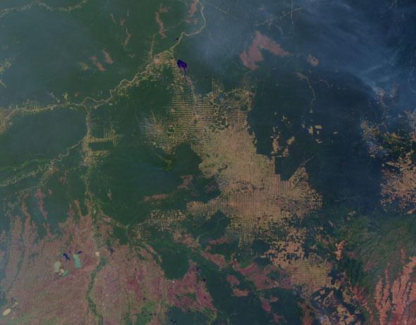
2. BRAZIL'S MATO GROSSO
State Pop: 2,500,000
Area: 906,806.9 km² (350,027 mi²)
Economy: Agribusiness, Leads Brazil in cattle production - 27 million head
- The major producer of soybeans in Brazil.
- Produces 51% of Brazil's and 3.9% of World's cotton.
- Home to large, vast cattle ranches. A tropical Texas, with room to grow.
- 30 years ago most of the State was in Mato Grosso (thick forest) or Cerrado (savannah brush). There were no highways, just dirt roads hundreds of kilometers long cutting through the dense tropical forest.
| 1992 | 2006 |
 |
 |
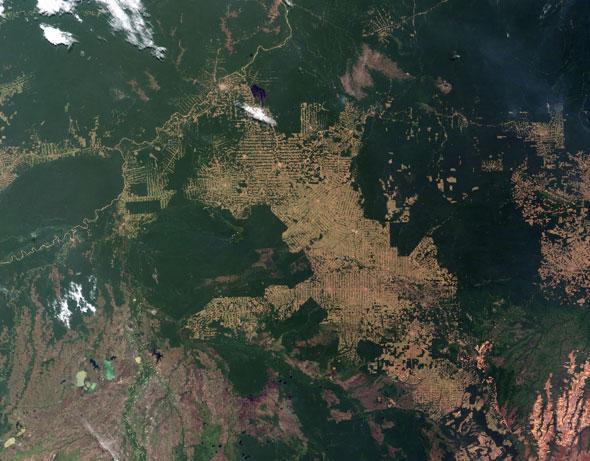
3. BRAZIL'S RONDONIA RAINFOREST
Urban population growth has led to the establishment of resettlement programs in several countries. Governments have made land available to poor families in overcrowded cities, who then have attempted to begin new lives from cleared forest. In Brazil the Transamazonian highway system was begun in the 1960s to enable development and settlement of the Amazon Rainforest. Part of the Transamazonian highway, called BR 364, penetrates the remote state of Rondônia in west-central Brazil. Since the highway's construction, this region has undergone significant deforestation. Main roads are cut into the forest, and parallel sets of access roads allow access....
In Rondônia, one of the most deforested Amazon regions, NASA captured roads and clearings replacing forest over the last decade. Forest shows up as dark green, cleared land as tan, and crops and pastures as light green. Some second-growth forest looks light green.
| 2001 | 2008 |
 |
 |
4. INDONESIA'S SUMATRA ISLAND
Sumatran rainforest, 1986: The fastest rate of deforestation in Indonesia is occurring in central Sumatra's Riau province, where some 4.2m hectares (65%) of its tropical forests and peat swamps have been cleared for industrial plantations in the past 25 years.
The Indonesian island of Sumatra is home to some of the world's fastest shrinking forests. Pulp and paper companies have set up shop in the Riau Province, gaining approval for logging operations. Increasing global demand for palm oil, an ingredient in biodiesel, has also given way to expansive palm oil plantations in the forests. The World Wildlife Fund recently released a report warning the destruction of Sumatra's natural forests is a significant factor in global climate change and is pushing rare species closer to extinction. Nearly 30% of the Riau's forests have been cleared for palm oil plantations, 24% for industrial pulpwood plantations, and 17% has been deforested but not replaced by any new vegetation. 78% of the Riau province was covered by forest in the 1980s but today it covers just 27%. In 2005 alone, it lost 11% of forest cover.
The Indonesian island of Sumatra is home to some of the world's fastest shrinking forests. Pulp and paper companies have set up shop in the Riau Province, gaining approval for logging operations. Increasing global demand for palm oil, an ingredient in biodiesel, has also given way to expansive palm oil plantations in the forests. The World Wildlife Fund recently released a report warning the destruction of Sumatra's natural forests is a significant factor in global climate change and is pushing rare species closer to extinction. Nearly 30% of the Riau's forests have been cleared for palm oil plantations, 24% for industrial pulpwood plantations, and 17% has been deforested but not replaced by any new vegetation. 78% of the Riau province was covered by forest in the 1980s but today it covers just 27%. In 2005 alone, it lost 11% of forest cover.
| 2001 | 2001 |
 |
 |
5. WEST VIRGINIA MOUNTAINS
From the beginning, farmers depended on the forest to supply building materials and the logs they floated to downstream mills to sell for cash. Expansion of the logging industry came slowly during the 19th century, but then accelerated to a crescendo between 1880 and 1920. During this period even the state's most remote mountain counties were integrated into the national markets by the 4,000 miles of railroad track that had been laid.
Cutting the timber resulted in major changes not just to the landscape but to all aspects of life. Towns sprouted up like wildflowers, new legislation and case law buttressed industrial expansion, and agriculture began its long decline. Many farmers thought that the country would be opened for farming once the timber was cut, but the soil was generally too poor for commercial farming, and farmers were unable to compete with their Midwestern counterparts in the markets to which they were now connected by the railroads.
The decline in agriculture was accelerated by the environmental disaster that deforestation left in its wake. Forest fires repeatedly swept over the land, 710 of them burning 1.7 million acres in 1908 alone. The streams became polluted and devoid of life, while floods ravaged the valleys below, and erosion washed away topsoil into the streams, silting up navigable watercourses. To save the inland waterways, the federal government embarked on a plan to protect the Ohio and Potomac watersheds by establishing the Monongahela National Forest in 1920. By then entire ecological systems had been destroyed.
NOT SINCE THE GLACIERS PUSHED toward these ridgelines a million years ago have the Appalachian Mountains been as threatened as they are today. But the coal-extraction process decimating this landscape, known as mountaintop removal, has generated little press beyond the region. The problem, in many ways, is one of perspective. From interstates and lowlands, where most communities are clustered, one simply doesn't see what is happening up there. Only from the air can you fully grasp the magnitude of the devastation. If you were to board, say, a small prop plane at Zeb Mountain, Tennessee, and follow the spine of the Appalachian Mountains up through Kentucky, Virginia, and West Virginia, you would be struck not by the beauty of a densely forested range older than the Himalayas, but rather by inescapable images of ecological violence. Near Pine Mountain, Kentucky, you'd see an unfolding series of staggered green hills quickly give way to a wide expanse of gray plateaus pocked with dark craters and huge black ponds filled with a toxic byproduct called coal slurry. The desolation stretches like a long scar up the Kentucky-Virginia line, before eating its way across southern West Virginia.
Central Appalachia provides much of the country's coal, second only to Wyoming's Powder River Basin. In the United States, one hundred tons of coal are extracted every two seconds. Around 70 percent of that coal comes from strip mines, and over the last twenty years, an increasing amount comes from mountaintop removal sites. In the name of corporate expedience, coal companies have turned from excavation to simply blasting away the tops of the mountains. To achieve this, they use the same mixture of ammonium nitrate and diesel fuel that Timothy McVeigh employed to level the Murrow Building in Oklahoma City—except each detonation is ten times as powerful, and thousands of blasts go off each day across central Appalachia. Hundreds of feet of forest, topsoil, and sandstone—the coal industry calls all of this "overburden"—are unearthed so bulldozers and front-end loaders can more easily extract the thin seams of rich, bituminous coal that stretch in horizontal layers throughout these mountains. Almost everything that isn't coal is pushed down into the valleys below. As a result, 6,700 "valley fills" were approved in central Appalachia between 1985 and 2001. The Environmental Protection Agency estimates that over 700 miles of healthy streams have been completely buried by mountaintop removal and thousands more have been damaged. Where there once flowed a highly braided system of headwater streams, now a vast circuitry of haul roads winds through the rubble. From the air, it looks like someone had tried to plot a highway system on the moon.
Active mining looks off-white in this time-series of coal mining in West Virginia from 1984 to 2009. The NASA pictures show "valley fills," streams filled with excess rock from the mountaintop removal, slowly building towards the mouth of the Mud River. More than 15.6 square miles where disturbed.
| 1984 | 1988 |
 |
 |
| 1996 | 2009 |
 |
 |
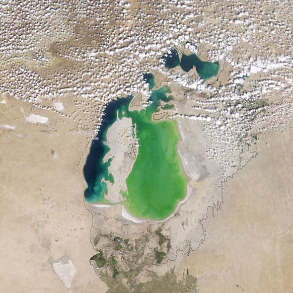
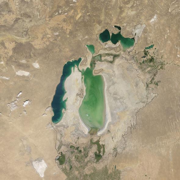
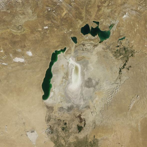
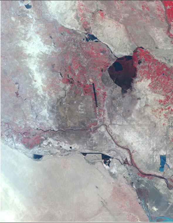
6. ARAL SEA
It was once the world's fourth-largest lake, but Central Asia's Aral Sea has shrunk by 90 per cent in the past 50 years what has been described as one of the planet's 'most shocking environmental disasters.'
The sea, which borders Uzbekistan and Kazakhstan and was once 26,000 square miles, has dried up significantly since the 1960s when the rivers that fed it were largely diverted in a Soviet project to boost cotton production in the arid region.
By 1997 it had shrunk to 10 per cent of its original size and split into a large southern Uzbek part and a smaller Kazakh portion.
The shrunken sea has ruined the once-robust fishing economy and left fishing trawlers stranded in sandy wastelands, leaning over as if they dropped from the air.
The sea's evaporation has left layers of highly salted sand, which winds can carry as far away as Scandinavia and Japan, and which plague local people with health troubles.
The construction of irrigation canals began in the 1940s, and by 1960 up to 60 cubic kilometres of water was being diverted to the land annually.
The sea's level drops by an average of 31-35 inches each year.
By 2000 the Northern and Southern Aral Sea had already separated. The NASA pictures show how they shrank even further between 2005 and 2009 because of severe drought, and then increased in the summer of 2010 after the drought breaks.
| 2000 | 2004 |
 |
 |
| 2009 | |
 |
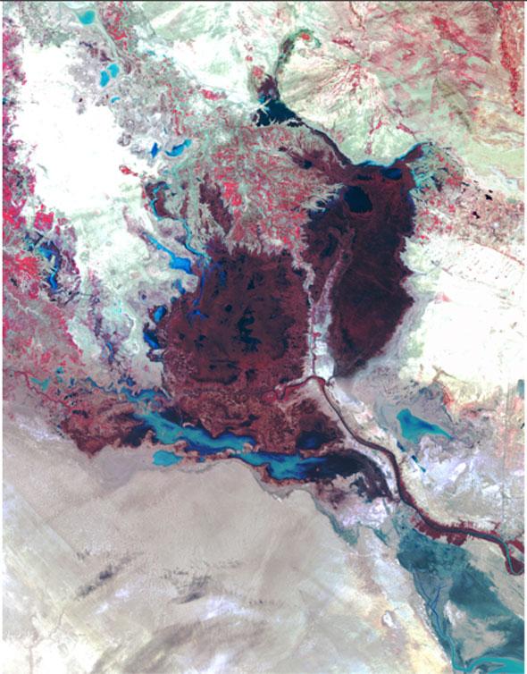
7. IRAQ MARSHES
The Mesopotamian Marshes, located between the Tigres and Euphrates Rivers in southern Iraq, were historically one of the world's most important wetland environments. The area of once over 20,000 square kilometers—thought by some to be the original Garden of Eden—provided habitat for millions of migrating birds and has been inhabited since the time of the Sumerians by thousands of people living on artificial islands of mud and reeds and depending on sustainable fishing and farming. Since the early 1990s, however, this important ecological and unique cultural jewel has been devastated by a series of thoughtless dam constructions and deliberate water diversions that has led to what many have come to regard as one of the most severe "ecocides" in human history. At the same time as the wetlands were being destroyed, the 5,000-year old way of life of the marsh dwellers was all but erased. During the last year, thousands of items of news coverage around the world have introduced and kept the topic of restoring the Mesopotamian Marshes alive in the public eye. Understood by all is the need to design and sustain an environmental restoration endeavor that balances the desire for maintaining traditional lifestyles within the longer context of modern development.
Saddam Hussein drained large areas of the Mesopotamia marshes, on Iraq's border with Iran, in part as a political move against the Marsh Arabs. Water diversion for irrigation and hydroelectricity had already taken a toll on the marshlands seen in the 2000 NASA image.
| 1973 | 2000 |
 |
 |
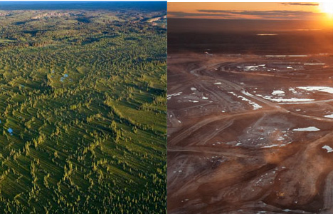
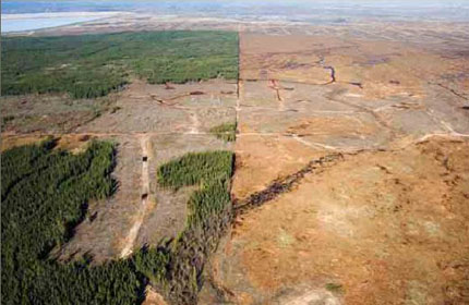
8. Canada's Athabasca Tar Sands
One of the most environmentally contentious issues today in Canada is the Athabasca Tar Sands. To access the oil-rich bituman the land in the tar sands area is completely torn up and the rivers are polluted. Residents are complaining of increased incidents of cancer in local populations. The tar sands are a black mark on the Canadian environment record for sure. But according to the Staples Theory Canada is highly dependent on the tar sands economically as well as politically. Even if the federal government wanted to shut down the tar sands, economic and political issues prevent them from taking a real stand for the sake of the environment and public welfare.
Producing crude oil from the tar sands a heavy mixture of bitumen, water, sand and clay found beneath more than 54,000 square miles of prime forest in northern Alberta an area the size of England and Wales combined generates up to four times more carbon dioxide, the principal global warming gas, than conventional drilling. The booming oil sands industry will produce 100 million tonnes of CO2 (equivalent to a fifth of the UK's entire annual emissions) a year by 2012, ensuring that Canada will miss its emission targets under the Kyoto treaty, according to environmentalist activists.
The oil rush is also scarring a wilderness landscape: millions of tonnes of plant life and top soil is scooped away in vast open-pit mines and millions of litres of water are diverted from rivers up to five barrels of water are needed to produce a single barrel of crude and the process requires huge amounts of natural gas. The industry, which now includes all the major oil multinationals, including the Anglo-Dutch Shell and American combine Exxon-Mobil, boasts that it takes two tonnes of the raw sands to produce a single barrel of oil. BP insists it will use a less damaging extraction method, but it accepts that its investment will increase its carbon footprint.
Before and After: reported book by Andrew Nikiforuk, Tar Sands: Dirty Oil and the Future of a Continent. He outlines any number of hackles-raising connections between authorities in Alberta and Canada and the enormous oil and gas companies that are currently raping a big chunk of the world's third largest watershed.
 |
 |
By Stephen Moore 18/04/2011
References:
http://www.businessinsider.com/satellite-photos-destroying-the-world-2011-3
1. Monarch Butterfly Biosphere Reserve - http://whc.unesco.org/en/list/1290
2. State of Mato Grosso - http://www.brazilintl.com/states/matogrosso/matogrosso.htm
3. Status of the World's Tropical Forests - http://www.britannica.com/EBchecked/topic/1673338/Status-of-the-Worlds-Tropical-Forests/219159/Resettlement-programs
4. International land Coalition - http://www.commercialpressuresonland.org/press/deforestation-sumatra-island
Denver Post - http://blogs.denverpost.com/captured/2010/10/05/captured-deforestation-in-sumatra/2470/
5. The West Virginia Encyclopedia - http://www.wvencyclopedia.org/articles/1867
Orion magazine - http://www.orionmagazine.org/index.php/articles/article/166/
6. Daily Mail - http://www.dailymail.co.uk/news/worldnews/article-1263516/How-Aral-Sea--half-size-England--dried-up.html
7. Mesopotamian Marshes & Modern Development - http://projects.gsd.harvard.edu/mesomarshes/
8. The Independent - http://www.independent.co.uk/environment/the-biggest-environmental-crime-in-history-764102.html
Big Green - http://greeneconomygroup.wordpress.com/2011/03/14/colossal-fossil-way-to-go-canada/
Greenpeace - http://gobeyondoil.com/blog/climate/dirty-oil-20100312